

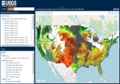
Fire Danger Forecast : Tool developed by USGS EROS and the USDA Forest Service that combines forecast weather data and satellite observations to depict the risk for large fire activity. Forecasts are produced up to seven days in advance and are updated daily.
Wildfire Risk To Communities: Developed by the USDA Forest Service, is a free, easy-to-use website with interactive maps, charts, and resources to help communities understand, explore, and reduce wildfire risk.
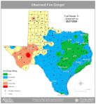
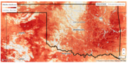
State Fire Danger Maps: County-level forecasts and current fire risk conditions are available through the Oklahoma and Kansas Mesonet and Texas A&M Forest Service websites.